


Keduhe River in Qujing
Chinese Name:可渡河
English Name: Keduhe River in Qujing
Kedu River, also known as Yangliu River or Kuadu River, is a tributary on the northern bank of the Beipan River. It originates from the eastern slopes of the Wumeng Mountains at Pingzi Tree in Guanyinshan, Xuanwei City. The river flows northeast through Shanmuping and reaches the Yunnan-Guizhou border 2 kilometers downstream from Tiechang. After merging with Heishi River, it turns southeast, then northeast, and flows through Xiaozhai before becoming a subterranean river section at Tiansheng Bridge. After re-emerging, it continues northeast and joins the Beipan River at Duge.
Watershed Overview
The watershed is located between longitudes 103°50′-104°40′ E and latitudes 26°23′-26°45′ N, spanning three areas: Xuanwei, Weining, and Shuicheng in Yunnan and Guizhou provinces. The total basin area is 3,076 square kilometers, with 1,969.2 square kilometers in Guizhou Province. The river is 154.6 kilometers long, with a boundary river segment of 105 kilometers. The total elevation drop is 986 meters, with an average gradient of 6.8‰. The average annual flow at the river mouth is 37 cubic meters per second.
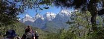
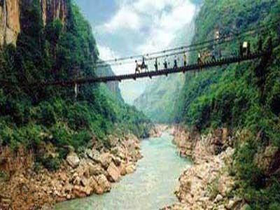
Upstream of Keduo, the river features a deep, narrow valley with sparse human habitation and limited farmland along the riverbanks. The riverbed is often composed of collapsed rock accumulations and has numerous rapids. Between Keduo and Tiansheng Bridge, the left bank is characterized by hanging rocks and steep slopes, while the right bank has gentler gradients. This section includes nine villages: Keduo, Yangliu, Damaizhai, and others. Below Wenchang Pavilion at the river mouth, there is the Kuadu Basin. The river valley here is mostly V-shaped with relatively gentle flow, and it has over 14 villages such as Kuadu and Caijiawan. Farmland is mainly concentrated around Kuadu, with the rest consisting of small plateaus. Below Tiansheng Bridge, the terrain is steep and the valley is narrow with a sharp gradient. The riverbed in the Muduo River to Chao River section is strewn with gravel and boulders, making the riverbank inaccessible and featuring numerous waterfalls and rocky ridges. The basin’s elevation ranges from a high point of 2,570 meters to a low point of 932.4 meters at the river mouth. The exposed geological strata in the basin include Carboniferous, Permian, Triassic, and Jurassic formations, with Permian and Triassic strata being predominant. There is widespread limestone distribution and karst development. The Guizhou part of the basin has a population of 980,000, predominantly engaged in agriculture, with 458,400 agricultural workers. There are 46,430 hectares of farmland, with more dry land than paddy fields; the paddy fields cover only 15,500 hectares. The effective irrigation area is 12,190 hectares, with a guaranteed irrigation area of 9,680 hectares. Transportation is mainly by road, with the East Sichuan-Yunnan Highway passing through the western edge of the basin, and the Nankun Railway extending into the southwestern Yunnan region. There is a hydrological station at Xiaozhai on the main river, with 21 years of measurement data.
Main River Overview
Kedu River is a tributary of the Beipan River. It originates from the Miebabian area in Longtan Township, Xuanwei City. The main river channel serves as the boundary river between Xuanwei and Guizhou’s Weining and Shuicheng. Flowing from northwest to southeast, it passes through Longtan, Delu, Tangtang, Yangliu, Shuanghe, Adu, Wenxing, and Puli before merging with the Beipan River at the La Long confluence. The Kedu River is 162.2 kilometers long with a drainage area of 2,975.8 square kilometers, of which 1,720.2 square kilometers are within Xuanwei City. The average gradient of the river channel is 7.5‰. Notable tributaries include Longtan River, Delu River, Tangtang River, Gande River, and Shuanghe River, creating a complex and winding dendritic drainage system flowing southeast.
Name and Origin:
- Kedu River, also known as Yangliu River or Kuadu River, is a northern tributary of the Beipan River.
- It originates from Pingzi Tree in Guanyinshan, Xuanwei City, located on the eastern slopes of the Wumeng Mountains.
Flow Path:
- The river flows northeast through Shanmuping and reaches the Yunnan-Guizhou border 2 kilometers downstream from Tiechang.
- After merging with Heishi River, it turns southeast and then northeast, flowing through Xiaozhai before becoming a subterranean river section at Tiansheng Bridge.
- It re-emerges and continues northeast to join the Beipan River at Duge.
Watershed Characteristics:
- Location: The watershed spans longitudes 103°50′-104°40′ E and latitudes 26°23′-26°45′ N, covering parts of Xuanwei, Weining, and Shuicheng in Yunnan and Guizhou provinces.
- Area: Total basin area is 3,076 square kilometers, with 1,969.2 square kilometers in Guizhou Province.
- Length: The river is 154.6 kilometers long, with a boundary river segment of 105 kilometers.
- Elevation Drop: Total drop is 986 meters, with an average gradient of 6.8‰.
- Average Flow: The annual average flow at the river mouth is 37 cubic meters per second.
River Sections:
- Upstream: Features a deep, narrow valley with sparse human habitation and limited farmland. The riverbed is often composed of collapsed rock and has numerous rapids.
- Middle Section: From Keduo to Tiansheng Bridge, the left bank is characterized by hanging rocks and steep slopes, while the right bank has gentler gradients. This section includes nine villages: Keduo, Yangliu, Damaizhai, and others.
- Kuadu Basin: Located below Wenchang Pavilion, this area has a V-shaped river valley with relatively gentle flow and contains over 14 villages such as Kuadu and Caijiawan. Farmland is mainly concentrated around Kuadu.
- Downstream: The terrain is steep with a narrow, deep valley and a sharp gradient. The riverbed in the Muduo River to Chao River section is strewn with gravel and boulders, making the riverbank inaccessible and featuring numerous waterfalls and rocky ridges.
Geological and Demographic Details:
- Elevation Range: The basin’s elevation ranges from a high point of 2,570 meters to a low point of 932.4 meters at the river mouth.
- Geological Strata: Includes Carboniferous, Permian, Triassic, and Jurassic formations, with Permian and Triassic strata being predominant. There is widespread limestone distribution and karst development.
- Population: The Guizhou part of the basin has a population of 980,000, predominantly engaged in agriculture. Agricultural workers number 458,400.
- Farmland: There are 46,430 hectares of farmland, with more dry land than paddy fields (15,500 hectares). Effective irrigation area is 12,190 hectares, with a guaranteed irrigation area of 9,680 hectares.
Transportation and Infrastructure:
- Transport: Primarily by road. The East Sichuan-Yunnan Highway passes through the western edge of the basin, and the Nankun Railway extends into the southwestern Yunnan region.
- Hydrological Station: There is a hydrological station at Xiaozhai on the main river, with 21 years of measurement data.
Main River Characteristics:
- Length: 162.2 kilometers.
- Drainage Area: 2,975.8 square kilometers, with 1,720.2 square kilometers within Xuanwei City.
- Average Gradient: 7.5‰.
- Tributaries: Notable tributaries include Longtan River, Delu River, Tangtang River, Gande River, and Shuanghe River, forming a complex and winding dendritic drainage system.


