10 Days Yunnan Cycling Tour along The Old Burma Road from Dali to Ruili
Tour Overview
The Burma Road The Burma Road (Chinese: 滇缅公路) was a road linking Burma with the southwest of China. Its terminals were Kunming, Yunnan, and Lashio, Burma. It was built while Burma was a...
Code of Tour: YET0000067611
Length of Travel: 10 Day
Destinations of Tour: Dali-Yangbi-Yongping-Baoshan-Longling-Tengchong-Yingjiang-Ruili
Departure City: Dali
Price of Tour: Request
Type of Tour:
Features of Tour:
The Burma Road
The Burma Road (Chinese: 滇缅公路) was a road linking Burma with the southwest of China. Its terminals were Kunming, Yunnan, and Lashio, Burma. It was built while Burma was a British colony to convey supplies to China during the Second Sino-Japanese War. Preventing the flow of supplies on the road helped motivate the occupation of Burma by the Empire of Japan 1942. Use of the road was restored to the Allies in 1945 after the completion of the Ledo Road. Some parts of the old road are still visible today.
History of Burma Road
The road is 717 miles (1,154 km) long and runs through rough mountain country. The sections from Kunming to the Burmese border were built by 200,000 Burmese and Chinese laborers during the Second Sino-Japanese War in 1937 and completed by 1938. The construction project was coordinated by Chih-Ping Chen. It had a role in World War II, when the British used the Burma Road to transport materiel to China before Japan was at war with the British. Supplies would be landed at Rangoon (now Yangon) and moved by rail to Lashio, where the road started in Burma.
In July 1940, the British government yielded, for a period of three months, to Japanese diplomatic pressure to close down the Burma Road to supplies to China. After the Japanese overran Burma in 1942, the Allies were forced to supply Chiang Kai-shek and the nationalist Chinese by air. United States Army Air Force cargo planes, mainly Curtiss C-46s, flew these supplies from airfields in Assam, India, over “the hump”, the eastern end of the Himalayas. Under British command Indian, British, Chinese, and American forces, the latter led by General Joseph Stilwell, defeated a Japanese attempt to capture Assam and recaptured northern Burma. In this area they built a new road, the Ledo Road which ran from Ledo, Assam, through Myitkyina and connected to the old Burma Road at Wandingzhen, Yunnan, China. The first trucks reached the Chinese frontier by this route on January 28, 1945.
From 1942–1944, 98 percent of all US lend lease to China went directly to US Army units in China, not the Chinese military.
Meaning of Burma Road
The Burma Road was a very important road during the WW2 linking Lashio, in eastern Burma (now Myanmar), with Kunming, in Yunnan province, China.
The road was 1,154 km (717 miles) long and was built during World War II to bring supplies to beleaguered China, to help them resist the Japanese invasion. Not much of the original road survives today, but parts of the route can still be travelled. Some parts of the old road are still visible today.
It was built as a gateway between Myanmar and the southwest of China, the rising empire on its border. It was one of the most remarkable engineering achievements of all time. More than 200,000 Chinese laborers embarked on a seemingly impossible task: to cut a 700-mile overland route — the Burma Road — from the southwest Chinese city of Kunming to Lashio, Burma. But when Burma fell in 1942, the Burma Road was severed. As the first step of the Allied offensive toward Japan, American general Joseph Stilwell reopened it, while, at the same time, keeping China supplied by air-lift from India and simultaneously driving the Japanese out of Burma.
Route Overview
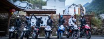
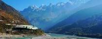
Cycling Route: Dali – Erhai Lake Loop – Baoshan – Tengchong – Yingjiang – Ruili – China-Myanmar Border (Dali至瑞丽, 云南中缅公路) Total Distance: Approximately 900KM Region: This route is located in the southwest of Yunnan Province, with an average altitude of around 1500 meters. It enjoys mild winters and cool summers, with a spring-like climate year-round. The route is rich in both cultural and natural attractions.
Key Highlights
1. Erhai Lake Loop (洱海环湖)
-
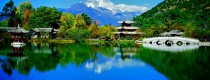
Description: Known for the saying “Xia Guan wind, Shang Guan flowers, Cangshan snow, and Erhai moon,” Erhai Lake is one of the clearest plateau lakes in Yunnan, with Grade 1 water quality. The loop around Erhai Lake is about 90KM, recommended to be completed over two days. The first day should end with an overnight stay at Shuanglang (双廊). The route offers stunning views of the crystal-clear lake, with Cangshan Mountain (苍山) towering in the distance. During winter, visitors can enjoy the beauty of “Cangshan snow, Erhai moon.” Along the way, you will encounter traditional Bai (白族) architecture and villages, adding to the cultural charm of the region.
2. Majestic Rivers (大江大河)
-
Description: This cycling route takes you along some of the grandest rivers in the region, including the Yangbi River (漾濞江), Lancang River (澜沧江), and Nujiang River (怒江). Cycling along these mighty rivers, you’ll experience the grandeur of nature and the feeling of being small in comparison to the vast landscape.
3. Historic and Charming Towns (风情古镇)
-
Description: The journey passes through several historic towns known for their charm, such as Dali (大理), Tengchong (腾冲), and Heshun (和顺). These ancient towns are perfect places to relax, enjoy a cup of tea, or sit on a comfortable chair and soak up the sun. The peaceful atmosphere and the picturesque surroundings will leave you with unforgettable memories.
4. Stunning Mountain Views (壮丽高山)
-
Cangshan Mountain (苍山): Also known as Diancang Mountain, Cangshan is the main peak of the southern Yunnan Mountains. The highest peak, Malong Peak, stands at 4122 meters above sea level. There are 19 peaks, and each valley between two peaks has a stream that flows into Erhai Lake.
-
Gaoligong Mountain (高黎贡山): Part of the southern Qinghai-Tibet Plateau, Gaoligong Mountain is known for its rich forest resources and rare plants. Among the treasures here are the world’s largest rhododendron trees, ancient plant species like the “green longevity star” – the rare Bald Cypress (秃杉), as well as the original species of Yunnan cherry blossom and camellia.
5. Ethnic Minority Cultures (少数民族人文风情)
-
Description: Along the route, you’ll encounter diverse ethnic minority communities, including the Bai (白族), Lisu (傈僳族), Wa (佤族), Yi (彝族), and Dai (傣族) peoples. The unique architecture, customs, and lifestyles of these ethnic groups provide fascinating cultural insights and enrich the journey.
6. China-Myanmar Expedition History (中缅远征军)
-
Description: The old Burma Road, which this route follows, was once famous for its role in the China-Myanmar Expedition during World War II. The section between Baoshan (保山) and Tengchong (腾冲) still features the abandoned northern route of the Stilwell Road, now known as County Road 192. This road sees little traffic now, making it a unique experience. In Tengchong, the National Martyrs’ Cemetery (国殇园) honors the spirits of over 2,000 Chinese soldiers from the expedition. Along the route, you’ll also pass the site of the famous Battle of Songshan, where old artillery shells can still be found by the roadside.
7. China-Myanmar Border (中缅边境)
-
Description: The final destination of this journey is the China-Myanmar border, where you can experience the unique cultural blend of Myanmar (缅甸). For those who have never been abroad, this is a perfect opportunity to step foot in a foreign country and feel the cross-border atmosphere.
Daily Itinerary
Day 1: Arrive in Dali (大理)
-
Arrival in Dali and settle into accommodation. Explore Dali’s Old Town (大理古城), a beautiful spot with a mix of traditional Bai architecture and modern shops.
Day 2: Dali to Shuanglang (大理-双廊) – 90KM
-
Cycle along the Erhai Lake Loop, with stunning views of the lake and surrounding mountains. Stop for breaks and enjoy local Bai culture.
Day 3: Shuanglang to Baoshan (双廊-保山) – 120KM
-
Cycle towards Baoshan, passing scenic countryside and small ethnic villages along the way.
Day 4: Baoshan to Tengchong (保山-腾冲) – 120KM
-
Ride through rugged landscapes and historic sites related to the China-Myanmar Expedition. Arrive in Tengchong, a town known for its hot springs and historical significance.
Day 5: Tengchong to Yingjiang (腾冲-盈江) – 100KM
-
Travel through mountainous roads, experiencing the unique cultural elements of the Wa and Yi minorities.
Day 6: Yingjiang to Ruili (盈江-瑞丽) – 70KM
-
Finish the journey at Ruili, near the China-Myanmar border, experiencing the vibrant cultural mix of both countries.
Day 7-10: Explore Ruili and the China-Myanmar Border (瑞丽-中缅边境)
-
Spend the last few days exploring Ruili and its surroundings, visiting the China-Myanmar border, the local markets, and immersing yourself in the cultural heritage of the area.
Route Area Climate
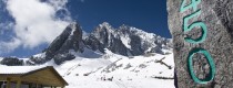
This route has an average altitude of about 1500 meters, with the highest point at 3100 meters, located at the Gaoligong Mountain Pass (高黎贡山垭口). During winter, crossing the pass may encounter snow. The areas below 2000 meters enjoy a spring-like climate with abundant sunshine. From October to March, the dry season is ideal for cycling. There is a large temperature difference between morning and evening, often exceeding 15 degrees Celsius, with the saying “One rain turns it to winter” being common.
Best Time for Cycling
The best time for this cycling tour is from October to March. During autumn and winter, the route enjoys sunny weather and vibrant colors, with the added bonus of witnessing the beauty of Cangshan Snow (苍山雪).
Transfer Stations
There are long-distance bus stations in Dali (大理), Baoshan (保山), Yingjiang (盈江), and Ruili (瑞丽) that provide service back to Kunming. Baoshan also has an airport with direct flights to major cities across the country. Dali has a relatively rare train station in Yunnan.
Suggested Cycling Duration
The entire route spans approximately 900KM. It is recommended to complete it in about 12 days, with stops in places such as Dali (大理), Erhai Lake (洱海), Heshun (和顺), Tengchong (腾冲), and Ruili (瑞丽), all of which are worth visiting.
Cycling Content
Cultural Aspects:
-
China-Myanmar Expedition History (中缅远征军历史遗迹)
Along the route, explore historical sites related to the China-Myanmar Expedition, which played a significant role during World War II. -
Ethnic Minority Cultures (少数民族风情)
The route passes through areas inhabited by various ethnic minorities, showcasing their unique customs and lifestyles.
Natural Landscapes:
-
Mountains (高山):
The route features breathtaking mountain views, including Cangshan Mountain (苍山) and Gaoligong Mountain (高黎贡山). -
Lakes and Rivers (湖泊河流):
The cycling route also takes you past several significant bodies of water, including Erhai Lake (洱海), Yangbi River (漾濞江), Lancang River (澜沧江), and Nujiang River (怒江).
Route Evaluation
The total distance of the route is approximately 900KM, featuring a blend of natural beauty and cultural richness. The entire route consists of mountain roads, requiring considerable physical effort. However, the difficulty is lower compared to traditional cycling routes such as the Sichuan-Tibet (川藏) and Yunnan-Tibet (滇藏) routes. The highest point on the route is around 3200 meters (Gaoligong Mountain), and the lowest point is around 800 meters (Yingjiang County).
Cycling Difficulty:
-
Cycling Level: Level 4
-
Physical Intensity: ★★★★
-
Technical Difficulty: ★★★
-
Excitement and Thrill: ★★★
-
Historical and Cultural Significance: ★★★★
-
Natural Scenery: ★★★★
Recommended Group Size:
4 to 9 people
Travel Itinerary (Leisure Version)
Day 1: Arrive in Dali
Rest in Dali Ancient Town (大理古城). Dali Ancient Town is located 12 kilometers north of Dali New City (Xia Guan, 下关). After picking up your bike at the Xia Guan train station, ride directly to the Ancient Town to rest.
Day 2: Around Erhai Lake
Cycle around Erhai Lake (洱海) along the Dali-Li line. As you leave the city, you can see the famous Dali Three Pagodas (大理三塔) from a distance. The first stop out of the Ancient Town is Xizhou (喜洲), where you can visit famous Bai ethnic houses. It is recommended to avoid the main roads and instead take the small rural paths that wind through Bai villages, often revealing stunning views of Erhai Lake. Spend the night in Shuanglang (双廊), where you can taste the famous Sculpted Plum Wine (雕梅酒). The next day, continue to Xiao Putuo (小普陀), enjoying the beautiful scenery along the way, and return to Xia Guan (下关) to stay overnight. A stay at a state-owned guesthouse is recommended, such as the Post Hotel (邮政宾馆), which offers affordable rooms during the off-season (20 RMB per person).
Day 3: Dali to Wayaotown
Leave Xia Guan (下关) and take National Route 320. After leaving the city, you will encounter about 40KM of gravel roads. The terrain remains hilly all the way to Yongping (永平). The first major climb is Huanglian Slope (黄莲坡), approximately 21KM long. There is a guesthouse run by a Lisu ethnic woman at the top of the slope, offering dormitory-style accommodation for 10 RMB per person. After lunch, descend the 17KM slope and cross the Lancang River Bridge (澜沧江大桥). Continue cycling along the Lancang River to reach Wayaotown (瓦窑镇), located between Yongping and Baoshan. The town is surrounded by snow-capped mountains in winter, and the town offers basic food and accommodation facilities, including a karaoke hall.
Day 4: Wayaotown to Sandadi
Today, you will cross two mountains. The first climb is from Wayaotown, with some gravel roads along the way. After descending, you will reach a small unnamed town, then tackle the second mountain, passing vast wheat fields and other crops. At the mountain pass, you can enjoy a panoramic view of colorful mountains. After descending, you will come to a junction with a sign indicating X192 milestone. Following the old, abandoned Stilwell Road (史迪威公路) will lead you to Tengchong (腾冲). Continuing on the main road will bring you to Sandadi (三达地), a town located on the Nujiang River (怒江). There are two guesthouses in the town, with average facilities.
Day 5: Sandadi to Longchuanjiang Town
Cross the Nujiang River Bridge (怒江大桥) and encounter a military check by the People’s Armed Police (武警). You no longer need a border pass; an ID card or student ID is sufficient. Today, you will tackle the highest point of the entire journey, Gaoligong Mountain (高黎贡山), with a 36KM uphill stretch. Along the way, you will pass Baihua Town (白花镇) and the Songshan Battlefield (松山战场), where you can find bullet shells. At the mountain pass, which is 3200 meters above sea level, there is a teahouse where you can rest. Descend to reach Longchuanjiang Town (龙川江镇).
Day 6: Longchuanjiang Town to Tengchong
Today’s ride is easy. From Longchuanjiang Town (龙川江镇), climb a small hill and reach Tengchong (腾冲). Historically known as Tengyue Prefecture (腾越州), the ancient town of Heshun (和顺) is a must-visit, home to China’s largest village library, Heshun Library (和顺图书馆). Don’t miss experiencing the Volcanic Hot Sea (火山热海) and the Wetland (湿地) scenery. Be sure to try the famous local snack, Da Jiu Jia (大救驾). You can also visit the Guoshang Park (国殇园), which honors the memory of over 2,000 soldiers from China and Myanmar.
Day 7: Tengchong to Yingjiang
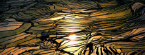
Leaving Tengchong (腾冲), you will cycle along the Gaoligong Mountain’s foothills. There are no long climbs but many short hills. In winter and spring, you will see fields of blooming rapeseed flowers (油菜花). The scenery along the route, especially near the Ruili River (瑞丽江) and Dayingjiang Scenic Area (大盈江风景区), is picturesque, with high mountains and clear waters. Highlights include the Dai ethnic bamboo houses (傣家竹楼) and the Yingjiang Tiger Jumping Stone (盈江虎跳石), as well as the caves in the area.
Day 8: Yingjiang to Ruili
After leaving Yingjiang (盈江), cross several small hills before reaching Husa (户撒), a small town before Zhangfeng (章凤). Husa is known for producing Achang ethnic knives (阿昌族刀具). Along the way, you will see many small Buddhist stupas in Dai settlements. After leaving Husa, climb a small hill to reach Zhangfeng, which is a medium-sized county. If it’s late, you can stay in Zhangfeng; otherwise, continue towards Ruili (瑞丽). The area around Ruili has excellent visibility, and at night, the starry sky is stunning. On clear nights, you may even be able to ride without using headlights.
Day 9: Ruili to Jie’gao (China-Myanmar Border)
Ruili (瑞丽) is a border city near Myanmar, serving as an important trade hub for China and Southeast Asia. Jie’gao (姐告) is a national border port close to Myanmar, with a street known as “Myanmar Street,” where small goods from India, Thailand, and Myanmar are sold. For tourism, you can visit with a border entry permit without needing a passport. However, for visits to La Rong (腊戎), further inquiries are necessary. In Ruili, you may find Myanmar boys selling low-quality jadeite products wrapped in red paper.
Jie’gao is just three kilometers from Ruili. You can ask the People’s Armed Police for permission to take photos near the border monument or even step onto Myanmar’s land.
Day 10: Departure from Ruili
Take a direct bus from Ruili (瑞丽) to Kunming (昆明), with a journey time of about 19 hours. Along the way, you will pass through three anti-drug checkpoints, where armed police will inspect passengers. Be cautious, as drug traffickers sometimes use women with children to smuggle drugs into bags.
Service Included:
- Admission fees for all of the sightseeing spots listed in the itinerary;
- Meals as listed in the itinerary;
- Accommodation with breakfast as listed in the itinerary;
- Private English-speaking tour guide and vehicle for transfers & sightseeing;
- Service charge & government taxes;
- Luggage transfers between airports and hotels;
- Two bottles of mineral water each day;
- Train tickets from Kunming to Dali, Shangri-La to Kunming.
Service Excluded:
- Any arrival and departure international airfares or train tickets;
- Chinese visa fees;
- Excess baggage charged by Airlines;
- Single room supplement;
- Tips to guides and drivers;
- Personal expenses and gratuities to service staff;
- Personal travel insurance;
- All optional programs.