

Hiking Travel Tips and Tour Routes of Cangshan Mountain in Dali
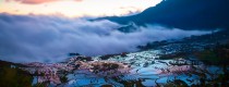
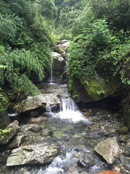
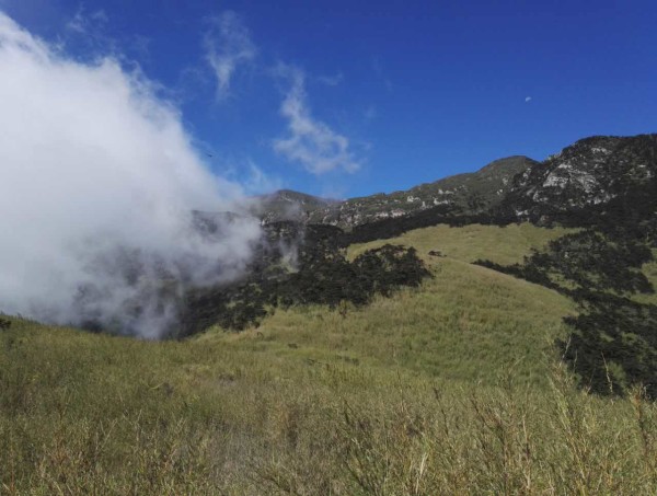
Cangshan Mountain in Dali has various geological and geomorphological features such as glacier landform, fault peak cluster, Cangshan Waterfall, Cangshan metamorphic rock, marble geology, wrinkled mountain landform, etc. The forest at the foot of the mountain is verdant, with waterfalls, clear springs and Longtan Huaxi in ten steps and one scene. At the peak of the mountain, the sea of clouds billows in summer and the azalea is brilliant. In winter, the snow is covered with snow and the beauty is very hard to express.
As the south side is adjacent to the Ximatan cableway station and there are mature hiking trails connecting the Cangshan jade belt tour road, the trail directly down to yinqiao town in the north side is also easy to identify and is favored by outdoor mountaineers.
One. The roue of taking the three-peak to the south.
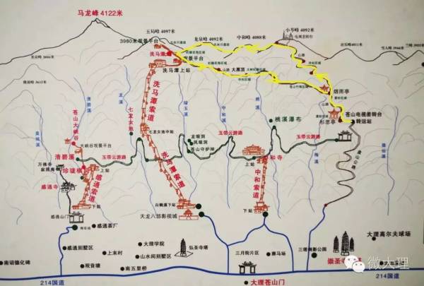
From the ancient town to the 3200 platform above sea level (i.e. Cangshan TV turntable transfer station), there is winding mountain highway, which can be used to drive off-road vehicles and minibuses to save a lot of physical strength. Then 3200-Yanyu Pavilion-Xiaocen peak, the earth-rock trail goes straight up, which takes a lot of physical energy. It takes about 4 hours to climb from an altitude of about 3200 meters to over 4000 meters. If there is a team organization, you can camp in the poor turntable, with electricity and water.
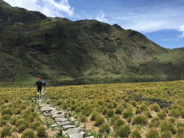
There is only one road along the ridge from the Chazhuantai to the south to Shimatang. It takes 1 hour to take photos while walking, and the altitude of Ximatan is 3950 meters. Ximatan-Cangshan Nature Education Center-Daiheiding-Yanyu pavilion-3200, with earth-rock hiking trails through virgin forests, streams and mountain streams, fir and bamboo forests; Due to the luxuriant trees, some sections of the road may get lost, so experienced people are needed to lead the way, and the whole journey takes about 3 hours for 7 kilometers.
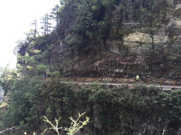
Now the cableway has been repaired to Ximatan. The most convenient way is to take the cableway to Ximatan and then climb the mountain. However, crossing the plank road of ximatan scenic area to enter the “unopened sightseeing area” will be blocked by the staff, because the disappearance of people who rush to mount Cangshan will happen every few months.
From Ximatan go down the mountain, you can choose to go from Yuju Peak to Yudai Road and Dali University directly along the cable tower. This is the nearest one. Because when the cableway was built, a construction and maintenance access road was opened, but some sections of the road passed the cliff.
From Ximatan go down the mountain, you can also go straight down to Zhonghe Temple from the Daheiding. The scenery in late autumn is very beautiful.
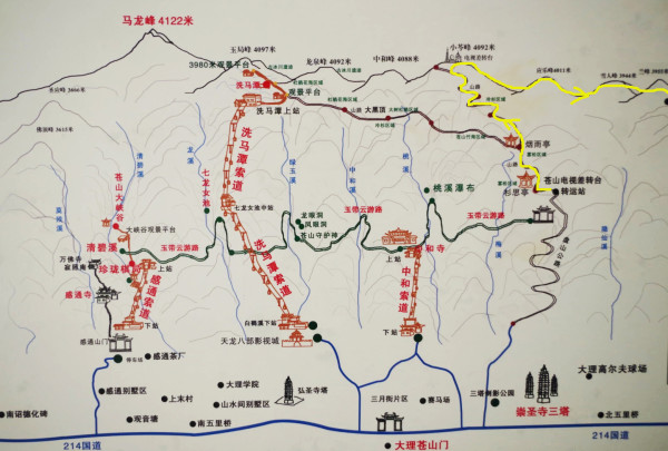
Two. The roue of taking the three-peak to the North.
(3800 right to yingle peak lane fork)
We will go climbing the mountain at 7:20,then reached 3800 altitude of Chayingle Peak, and reached Huanglongtan at 4:30 and returned to line 214 under Wahaha waterworks at 7: 20. ,the whole journey lasted nearly 27 kilometers and 12 hours.
Three.The roue of taking the Five-peak to the North.
Combined with the two lines from above, we go straight to Xiaocen Peak and go north through Xiaocen Peak, Yingle Peak, Yeti Peak, Lanfeng Peak and Sanyang Peak.
Reference time: 6:25 we will go down to Cangshan 3200, 8: 25-10: 30 Xiaocenfeng, 15: 00 p.m. to Huanglongtan, 16:30 to Heilongtan, downhill, 19: 00 at the quarry.
The roue of taking the seven-peak to the North and To climb the main peak
Day1.On the cableway to climb ximatan-Longquan peak-zhonghe peak-xiaoluo peak (TV differential turntable)-yingle peak-yeti peak-lanfeng-sanyang peak-huanglongtan-shuanglongtan
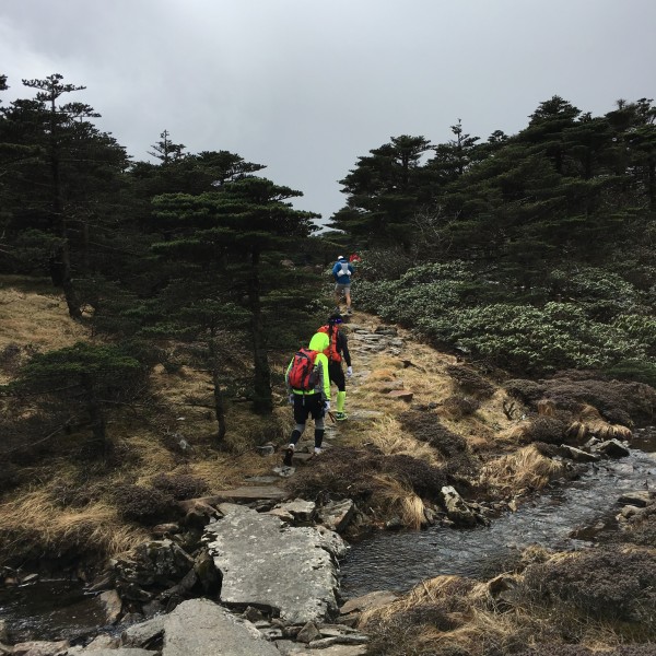
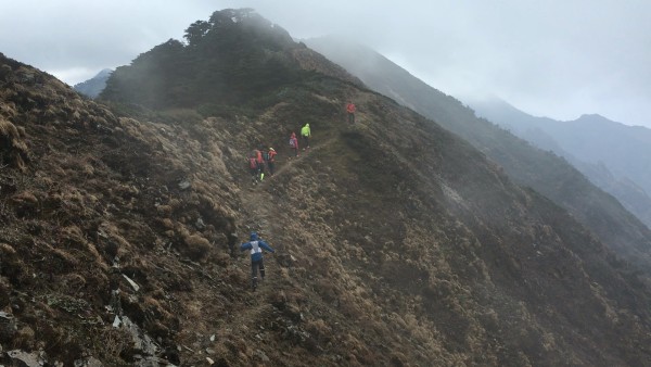
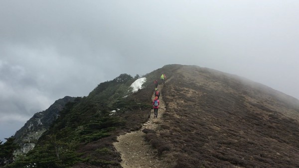
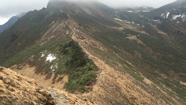
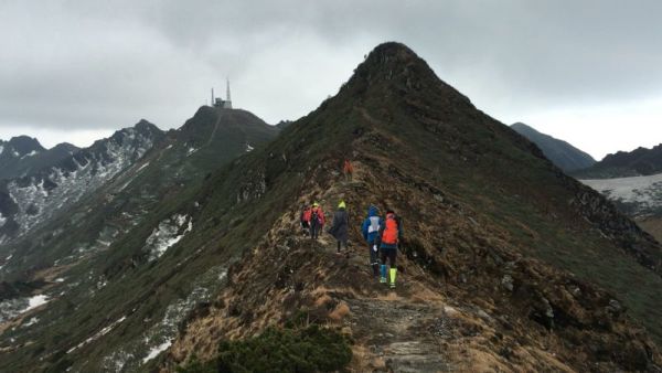
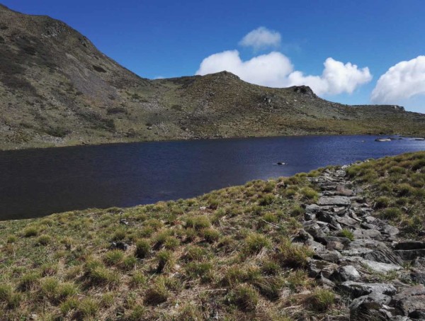
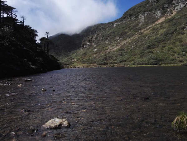
This road is basically walking on the ridge of Cangshan Mountain, with a distance of about 8 kilometers. Starting from Ximatan, we reach the high Dafeng pass at an altitude of 4070m. After crossing the pass, we cut down the slope and move on, then we reach Longquan Peak. Further on, you can see a towering TV tower-Cangshan TV Station, which was once the highest TV tower in the country and was located at the summit of Xiaocen with an altitude of 4092 meters. Ridge such as tough, exposure is very strong, strong winds blow, hikers have to use hands to help to walk, winter and spring season is biting cold. The camping that night was in the quiet and beautiful Shuanglongtan.
Day2. Shuanglongtan-Heilongtan-Bamboo Forest-Mountain Path-Qianshuichi Factory-Yinqiao Town
All the way down, through Shuanglongtan and Heilongtan, through a bamboo forest and then along a mountain path to Qianshuichi Factory, down 1648 steps, to the end of Yinqiao Town, a distance of 9 kilometers. The black dragon pool, the double dragon pool and the yellow dragon pool are all hidden in the big bosom of sanyang peak. therefore, sanyang peak has become the most beautiful place for Cangshan mountain. However, the altitude of the sea wave here is over 3900 meters, so it is not bad to go down the mountain. It would be much more difficult to go up the mountain road in reverse.
There are many extend ways to this route:
1. It is also possible to cross from north to south: Yinqiao Town-Qianshuichi Factory-Mountain Path-Bamboo Forest-Heilongtan-Shuanglongtan-Huanglongtan-Sanyang Peak-Lanfeng-Yeti Peak-Yinglefeng-Xiaoluo Peak (TV Turntable)-Zhonghe Peak-Longquan Peak-Shimantan cableway station. However, to enter the mountain from Lingquan Creek in Yinqiao Town, you must first climb 1648 steps to Qianshuichi Factory, then enter the deep forest and climb along the rugged mountain path, which requires much physical strength, endurance and perseverance.
2. If you have enough time and physical strength, you can start from Tianlong Babu Film and Television City, and walk along the pylon of the Shimantan cableway to Shimantan, a distance of about 6 kilometers. It can also be Wuwei Temple: Wuwei Temple-Ge Laoya-Old Mining Factory-Mountain Path, with the same route behind; It became a three-day route.
3. After arriving at Xiao ‘ao Peak (TV station), there is another mountain road to choose from: Xiao ‘ao Peak-3200m Alpine Post Station-Panshan Highway-Santai-Dali Ancient City.
4. If organized by the outdoor association, you can camp in Ximatan. The next morning, you can go straight to the highest mountain in Cangshan, Malong Peak (4122 meters above sea level), for about 3 hours and pass through Yuju Peak. On the return trip, you can go down to Gantong Temple directly along Qingbi Stream. This road is difficult to walk through several waterfalls and cliffs.
The best time to climb Cangshan is from March to May and from October to November each year when the weather is clear. June to August is when all kinds of azaleas are in full bloom in Cangshan, but there is more rain, which is not conducive to camping on the mountain.
Cangshan’s climate is changeable in summer and autumn. It is very changeable. It is sunny at the foot of the mountain. The mountain may be foggy, hail and snowy. There is 20 cm thick snow on the mountain top, which cannot be seen on the mountain foot. At night, the temperature is very low, so you should bring more warm clothing, and at the same time prepare lighting appliances, preferably rechargeable LED lights, communication tools are essential, and medicine preparation points for preventing and treating trauma. And hiking shoes must be awesome. In addition, raincoats are essential.
Cangshan longitudinal route is located in a high altitude area, with an average altitude of 3500-4000 meters and a maximum altitude of 4122 meters. hikers are ready to cope with altitude reaction.
Because of the changeable climate, it is very risky for inexperienced people to enter the unopened tourist area and climb Cangshan Mountain. Friends who go for the first time suggest organizing a group and looking for a professional guide to recommend Dali Deep Outdoor Sports Club. Tel.: 0872-2122787, 2183809, 8811226.
Tips for outdoor adventure camping equipment:
1. Personal equipment: backpacks (with rain cover), tents, moisture-proof pads, sleeping bags (comfortable -10 degrees), assault clothing, assault pants, down jacket, hiking shoes, thermal underwear, fleece-catching clothing, fleece-catching pants, spare socks, quick-drying clothing, headlights, rain gear, hiking sticks, sunglasses, personal special drugs, water bottles, chopsticks (or spoons), personal daily necessities, sunscreen, cameras (with batteries), cell phones (with batteries), compression bags, waterproof bags, garbage bags, hats, gloves, headlights, thermos pots, stoves, pots, etc. Realgar is used to prevent poisonous snakes when preparing for camping.
2. Recharge: Heat loss is rapid in plateau areas. For carrying heavy loads, you need to bring your own high-calorie food to supplement your physical strength. Chocolate, compressed biscuits and vitamins can be properly prepared.
see more about biking tour
Seeing Dali on a bike makes top choice for tourists
Top Bike Tour Routes around Kunming City
http://360.mafengwo.cn/travels/info.php?id=6577040
Click to rate this post!
[Total: 0 Average: 0]


