


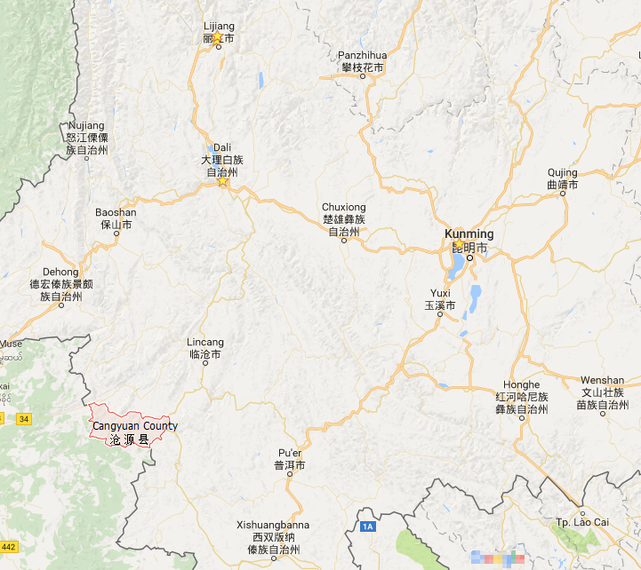
Location Map of Cangyuan County in Yunnan
Geographic Coordinates
Cangyuan County (沧源县) is located in the southwestern part of Yunnan Province, China. The county lies within the coordinates:
- Longitude: 98°52′E to 99°43′E
- Latitude: 23°04′N to 23°40′N
Surrounding Regions
Cangyuan is surrounded by several key regions in both Yunnan and Myanmar:
- North: It borders Gengma Dai and Wa Autonomous County (耿马傣族佤族自治县).
- East: It is adjacent to Shuangjiang Lahu, Wa, Blang, and Dai Autonomous County (双江拉祜族佤族布朗族傣族自治县).
- Southeast: It borders Lancang Lahu Autonomous County (澜沧拉祜族自治县).
- West and South: The county shares a border with Myanmar’s Shan State, particularly with Menglian County and the Nandeng Special Zone. The China-Myanmar border in Cangyuan stretches over 147.08 kilometers.
Geographical Features
Cangyuan County is characterized by mountainous terrain, steep slopes, and dense forests. The Nujiang River also runs through the area, contributing to the rich biodiversity and ecological diversity.
This unique location, combined with its proximity to Myanmar, makes Cangyuan a region of cultural and geographical significance.

Click to rate this post!
[Total: 0 Average: 0]


