


Gucheng District Climate
1.Geography
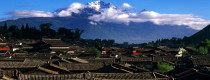
Gucheng District is located in the transitional region of the northwest Yunnan from the Hengduan mountain range to the Yunnan-Guizhou plateau. The region has complex topography and landform including hilly country, basin, and valley. The highest point of the whole area is Benlike Village of Qihe township at 3, 200 meters high, and the lowest is the exit of Jinsha River of Jinsha Township at 1219 meters high.
2. Climate
Gucheng District enjoys a plateau monsoon climate of low latitude, with an average annual temperature of 12.6 degrees centigrade and an average annual rainfall of 950 mm. It is pleasant with abundant rainfalls and cool summer, non-cold winter. The three-dimensional climate is obvious here, cold in the alpine mountains at above 3200 meters high and mild in the basin at the height of 2400 meters. While in the hilly area of below 1800 meters, it is hot in the summer and warm in the winter with strong solar radiation. The annual sunshine of basin is 2,500-2,700 hours, which amount is the No.1 of the whole Yunnan province.
3. Best Time to Visit
It is suitable to travel Gucheng District all the year round.


