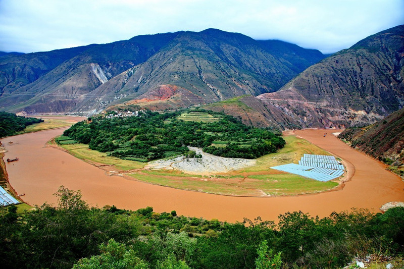
Honghe (Red) River in Yunnan

The Red River (Honghe): A Vital Asian Waterway Connecting China and Vietnam

Known as the Honghe in Chinese, the Red River is a significant Asian river originating in Yunnan Province, China, flowing through Vietnam, and emptying into the Gulf of Tonkin. It holds profound geographical, historical, economic, and cultural significance for both nations.

I. Geographical Overview: A Natural Artery Across China and Vietnam

Origins and Main Stream

  • The river begins in the mountains south of Dali, Yunnan, formed by the confluence of tributaries like the Leqiu, Xi, and Juli Rivers, which merge to create the Lishe River—the official start of the Red River.
  • Flowing southeast, it traverses ethnic minority regions in Yunnan (home to the Yi and Dai peoples) before entering Vietnam’s Lào Cai Province at Hekou Yao Autonomous County.
  • In Vietnam, it joins the Da River (Black River) and Lô River near Việt Trì City in Phú Thọ Province, then flows through Hanoi and into the Gulf of Tonkin. Total length: ~1,140 km (692 km in China).

Basin Characteristics

  • Chinese Section: Mountainous and gorged, rich in hydropower potential, with 湿润 (humid) climates; 70% of annual water flow occurs in the rainy season (June–October).
  • Vietnamese Section: The 中下游 (mid-lower reaches) form the vast Red River Delta, a crucial agricultural heartland for Vietnam.

II. History & Transportation: The Rise and Fall of a Trade Route

19th-Century Golden Trade Corridor

  • French explorers used the river to access China; in 1873, Paul Doumer navigated to Manhao Town (Gejiu City), opening Sino-Vietnamese trade.
  • As the core commercial route between French Indochina and Yunnan, goods like tea, minerals, and opium were transported via junks (dry season, November–May) and steamers (rainy season, when higher water levels allowed navigation up to Manhao).
  • Its role declined after the 1910 opening of the Kunming–Haiphong Railway, though it remains vital for local transportation.

Key Hubs

  • Haiphong Port: The closest seaport to Kunming in the early 20th century, linking Southwest China to Southeast Asia.
  • Manhao Town: Historically the northernmost navigable point, serving as a land-sea transit hub for 19th-century Sino-French trade.

III. Hydraulic Projects: Harnessing Water for Power and Ecology

Chinese Section: A Hub for Hydropower Development

  • Major Dams (for power generation and flood control):
    • Da Wan Dam, Dachunhe I/II Dams
    • Nansha Dam (in Yuanyang County, creating a large reservoir)
    • Madushan Dam (a key project in cascade hydropower development)
  • Tributary Development: Dams on the Lixian and Tengtiao Rivers complement main-stream projects, boosting Yunnan’s clean energy sector.

Vietnamese Section: Integrated Water Management

  • Thác Bà Dam (1972): Vietnam’s first major hydropower project, forming Thác Bà Lake (the country’s 2nd-largest reservoir) for electricity and irrigation.
  • Downstream Dikes: Protect the Red River Delta from floods and support agricultural irrigation, critical for Vietnam’s rice production.

IV. Towns & Cities Along the River: Ties of Civilization and Development

Key Towns in Yunnan, China

  • Hekou Yao Autonomous County: A vital Sino-Vietnamese border town with a Class-I national port, directly connected to Vietnam’s Lào Cai via rail and road.
  • Nansha Town (Yuanyang County Seat): Located near the Nansha Dam reservoir, in the heart of the UNESCO-listed Honghe Hani Rice Terraces, blending mountain scenery and ethnic culture.
  • Manhao Town (Gejiu): A historic shipping hub with century-old docks and French colonial architecture, preserving the legacy of Sino-Vietnamese trade.

Core Regions in Vietnam

  • Hanoi: Built along the river, featuring landmarks like the Long Biên Bridge and Hoàn Kiếm Lake; 80% of the city’s water supply relies on the Red River.
  • Red River Delta Provinces:
    • Phú Thọ Province: Việt Trì City, where the Red River meets the Lô River, a major industrial center.
    • Hải Dương & Thái Bình Provinces: Agricultural powerhouses, producing 1/3 of Vietnam’s rice.
    • Lào Cai Province: Borders Yunnan’s Hekou, thriving on cross-border trade and tourism.

V. Epilogue: A River of Culture and Future Prospects

The Red River is more than a geographical feature; it’s a millennium-old bridge between China and Vietnam. From ancient caravan routes to modern hydropower projects, and from border towns to bustling cities, it has witnessed regional transformation. Today, under the Belt and Road Initiative, the riverfront is evolving into a new frontier for ecological conservation and economic cooperation, connecting Southwest China with Southeast Asia.
Click to rate this post!
[Total: 0 Average: 0]