-
- Home
- Yunnan Tours
Most Popular Yunnan ToursEssential Yunnan TripsFind Yunnan Tours by MonthFind Yunnan Tours by Duration
- Group Tours
Popular Yunnan Group ToursAll Yunnan Group Tours
- 1 Day Kunming Stone Forest Group Tour
- 1 Day Jade Dragon Snow Mountain Group Tour
- 2 Days Tiger Leaping Gorge Hiking Group Tour
- 4 Days Haba Snow Mountain Climbing Group Tour
- 6 Days Yuanyang Hani Rice Terraces Group Tour
- 8 Days Kunming-Dali-Lijiang-Shangri-la Group Tour
- 8 Days Yunnan Chinese-Speaking Group Tour
- 15 Days Yunnan-Tibet Small Group Tour
- Themes Tours
- City Tours
- Travel Guide
- Attractions
- Customize
 7 Days GolfingTour
 8 Days Group Tour
 8 Days Yunnan Tour
 7 Days Shangri La Hiking
 11 Days Yunnan Tour
 6 Days Yuanyang Terraces
 11 Days Yunnan Tour
 8 Days South Yunnan
 7 Days Tea Tour
 8 Days Muslim Tour
 12 Days Self-Driving
 4 Days Haba Climbing
 Tiger Leaping Gorge
 Stone Forest
 Yunnan-Tibet
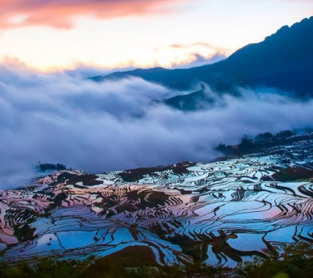
 Hani Rice Terraces
 Kunming
 Lijiang
 Shangri-la
 Dali
Dali
 XishuangBanna
 Honghe
 Kunming
 Lijiang
 Shangri-la
 Yuanyang Rice Terraces
 Nujiang
 XishuangBanna
 Spring City Golf
 Snow Mountain Golf
 Stone Mountain Golf
You Might Like
- 9 Days Yunnan (China)-Vietnam Overland Tour from Kunming to Hanoi

- 11 Days Yunnan Classic Tour with Holy Lugu Lake and Mosuo Matriarchal Society (Departure from Shangrila)
- XishuangBanna Gaozhuang Night Tour
- 5 Days Haba Snow Mountain Flowers Hiking and Climbing Tour with Heihai Black Sea
- 2 Days Chuxiong Nanhua Wild Mushroom Festival and Trade Fair Tour from Kunming
- 4 Day Meili Snow Mountain and Yubeng Village Hiking Tour from Lijiang
- 34 Days China Panorama Tour with Yunnan, Tibet and Yangtze River Cruise
- 2 Days The First Bend of Yangtze River Rafting Tour from Tacheng to Shigu


Nanpanjiang River in Qujing and Wenshan
Why is Nanpanjiang River So Special? Nanpanjiang River南盘江, also known as Wenshui温水 or Panjiang River盘江 in ancient time, is the main stream of Xijiang River西江. Nanpanjiang river originated from...

Liulangdong River Scenic Area in Qiubei County, Wenshan
Chinese Name: 丘北县六郎洞景区 English Name:Liulangdong River Scenic Area in Qiubei County, Wenshan Location Liulangdong Cave is situated 79 kilometers west of Qiubei County, Yunnan Province, near Xiaojiangkou Village in...

Tuoniangjiang River in Funing County, Wenshan
Chinese Name: 富宁县驮娘江景区 English Name: Tuoniangjiang River in Funing County, Wenshan Overview: The Tuoniangjiang River Scenic Area is a national AA-level tourist attraction located in Funing County, Wenshan. It...

Nanxihe River in Honghe and Wenshan
Chinese Name:南溪河 English Name: Nanxihe River in Honghe and Wenshan Nanxi River originates from Mingjiu Town in the eastern part of Mengzi County, Yunnan Province. Initially known as the...
Latest Articles
Contact Info
![]()
