 7 Days GolfingTour
 8 Days Group Tour
 8 Days Yunnan Tour
 7 Days Shangri La Hiking
 11 Days Yunnan Tour
 6 Days Yuanyang Terraces
 11 Days Yunnan Tour
 8 Days South Yunnan
 7 Days Tea Tour
 8 Days Muslim Tour
 12 Days Self-Driving
 4 Days Haba Climbing
 Tiger Leaping Gorge
 Stone Forest
 Yunnan-Tibet
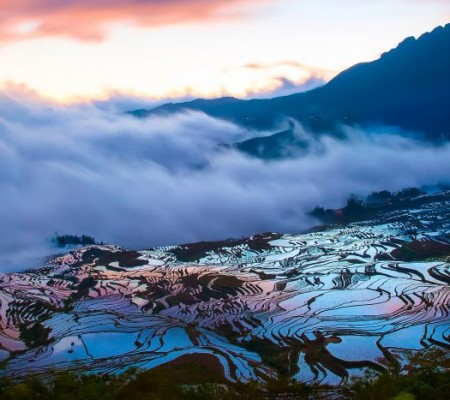
 Hani Rice Terraces
 Kunming
 Lijiang
 Shangri-la
 Dali
Dali
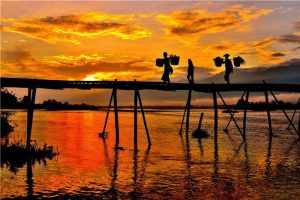
 XishuangBanna
 Honghe
 Kunming
 Lijiang
 Shangri-la
 Yuanyang Rice Terraces
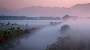
 Nujiang
 XishuangBanna
 Spring City Golf
 Snow Mountain Golf
 Stone Mountain Golf
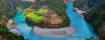
Dayingjiang River in Dehong

Attraction Overview
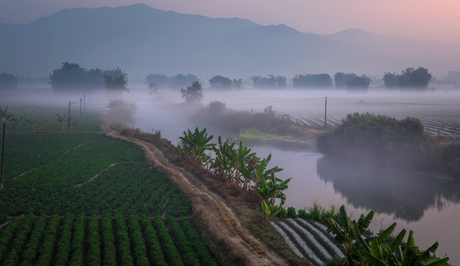
Dayingjiang River is a branch at the upstream of Irrawaddy River. It takes its rise from Danzha River and Binglangjiang River in Tengchong City. The two rivers join up with each other in the Old town of Yingjiang County, and then form the Dayingjiang River, which flows through Tiger Leaping Stone and then runs south to the Irrawaddy River in Burma. It finally flows into Bay of Bengal. Dayingjiang River is about 205 km long with 146 km in Yingjiang County. The river is 900 meters wide at its widest point and only 7.5 meters narrow at its narrowest point (Tiger Leaping Stone). There are two large branches, Binglangjiang River and Nandi River, at its upstream.
Chinese Name: 大盈江(Pinyin: Dayingjiang)
English Name: Dayingjiang River in Dehong
Attraction Type: River
Best Time to Visit: All year around
Recommended Visiting Time: One day
Opening Hours: All day long
Admission Fee: Free
Address: Dehong Jingpo and Dai Autonomous Prefecture, Yunnan Province
Why is Dayingjiang River So Special
Beautiful Dayingjiang River runs through Yingjiang County in west Yunnan border area. The river mouth is open and its surface is as flat as a mirror. In the sunny days, the limpid river lies as smooth as silk. Along the both sides of the river, distant mountains loom and forest is dyed black. Umbrella-like banyan forest looks lush and green. In the converging place of clouds and water, a bamboo raft is moving away. In the distance, since the river is set off by bamboo forest, a unique scene appears that the river overflows the bamboo grove and bamboo grove places the river in between. The hundred-meter-wide river is tightly locked by two pieces of rock cliff at Tiger Leaping Stone.
The distance between the two cliffs is only seven meters. The pouring torrent clashes the high mountains which rise abruptly along the gorge. The increasingly large fall of river generates glittering foam and the thundering uproar in the gorge can be heard several kilometers away. Considering the pouring torrent, deep riverway and giant stone emerging in the middle of the river, small waterfalls can be seen everywhere. The mountains stand facing each other on both sides of the river, posing a natural wonder of “a seam of sky if people look up and a thread of river when having a bird view.”
Where is Dayingjiang River-Location
Dayingjiang River is a branch at the upstream of Irrawaddy River. It takes its rise from Danzha River and Binglangjiang River in Tengchong City. The two rivers join up with each other in the Old town of Yingjiang County, and then form the Dayingjiang River, which flows through Tiger Leaping Stone and then runs south to the Irrawaddy River in Burma. It finally flows into Bay of Bengal. Dayingjiang River is about 205 km long with 146 km in Yingjiang County.
How to Get to Dayingjiang River
After arriving in Yingjiang County, it is convenient to get to Dayingjiang River by taxi, which takes about 40 minutes. For those people who are bike lovers, it is good way to get to Dayingjiang River by bike, which takes about 2 hours.
Introduction of Dayingjiang River
Dayingjiang River is a branch at the upstream of Irrawaddy River. It takes its rise from Danzha River and Binglangjiang River in Tengchong City. The two rivers join up with each other in the Old town of Yingjiang County, and then form the Dayingjiang River, which flows through Tiger Leaping Stone and then runs south to the Irrawaddy River in Burma. It finally flows into Bay of Bengal. Dayingjiang River is about 205 km long with 146 km in Yingjiang County. The river is 900 meters wide at its widest point and only 7.5 meters narrow at its narrowest point (Tiger Leaping Stone). There are two large branches, Binglangjiang River and Nandi River, at its upstream.
High trees and strange stones can be found along the two banks of Binglangjiang River. The water in the river runs very fast and high. After entering the dam area and joining with Nandi River, the river becomes quiet and winds to the west. The huge banyan trees are easily found along Dayingjiang River area, and Dai villages can be seen among the bamboo forests, which represent typical tropical and subtropical scenery. After winding through hundreds of primeval forests and canyons to arrive at Yingjiang Bamboo forest, the river turns slow and wide. On the two banks are endless farmlands and villages. A bamboo dam spreading thousands of miles stand on the riverbanks, and green islands can be seen in the middle of the river. Blue sky, white clouds, green bamboo and islands that are reflected in the river water, as well as small boats and Dai ethnic love songs constitute a fancy poem. In this scenic spot, there is not only original natural ecology, but also national customs. The integration of natural landscape and ethnic culture has become a feature of the area. This scenic area is based on the Yingjiang Section of Dayingjiang River, starting from Zhina Township in the north and Mangyun Township in the south. It also depends on the natural ecology of Dayingjiang, as well as numerous scenic spots. It mainly includes seven scenic areas: namely Zhina “Guangbang” drum cultural area, Dao Anren hometown, the original place of Dai opera, Old Town Xiang’e Lake area, customs area, Wanxiang old town area and monument of Margary affair. Water-Splashing Festival, Munaozongge Festival, national sports competitions, beach sports activities and other projects have also attracted many tourists.
Best Time to Visit
It is suitable to visit Dayingjiang River all year around. Every season has its unique beauty.
Nearby Attractions
XiangEhu Lake
Located in the southwest of Jiucheng Town of Yingjiang County, the beautiful XiangEhu Lake is the gateway and business card of Jiucheng Town. There are natural wetlands, sparkling natural lakes, and thousands of acres of lotus ponds with unique charm. XiangEhu Lake has a large amount of water, is not dry all year round, has good water quality, and contains many trace elements needed by the human body. There are more than ten kinds of wild fish in the lake, as well as birds such as egrets, yellow ducks and wild ducks, as well as aquatic plants such as lotus, reed and water hyacinth.
Yunyan Stupa
Yunyan Stupa in Yingjiang County, also known as Manmengding Stupa, is located on the top of Yunyan Mountain, 1 km east of Yingjiang County. “Yunyan” in Dai Language means an auspicious, joyful and fascinating place. It is one of the most important Buddhist pagodas of Hinayana in Yunnan. The pagoda was built in 1947 and it took eight years to complete the work. Although it is a modern product, it is rich in ancient style and is listed as a key cultural relic protection unit in Yunnan Province.
Yingjiang Hornbill Valley
Yingjiang Hornbill Valley is located on the bank of the Hongbenghe River in Yingjiang County, Dehong Dai and Jingpo Autonomous Prefecture, Yunnan Province. It belongs to the Hengduan Mountains extending from the Himalayas. The highest point is that the Daniangshan Mountain in Zhina Township is 3404.6 meters above sea level. The lowest point is that the Estuary of Nabanglashahe River is only 210 meters above sea level. The huge difference in altitude forms a cluster of northern tropical, subtropical and temperate climates, namely, the typical three-dimensional climate of the river. The forest coverage rate in Yingjiang County is 73.9%. There are many kinds of birds living here. At present, there are 550 species of birds found and recorded in Yingjiang, accounting for more than one-third of the national birds. The unique and precious Buceros bicornis, anthracoceros coronatus and Rhyticeros undulatus settle here. Therefore, it has the reputation of “Chinese Hornbill Valley”. Yingjiang is a beautiful and magical place, a paradise for birds, a kingdom of flora and fauna.


