 7 Days GolfingTour
 8 Days Group Tour
 8 Days Yunnan Tour
 7 Days Shangri La Hiking
 11 Days Yunnan Tour
 6 Days Yuanyang Terraces
 11 Days Yunnan Tour
 8 Days South Yunnan
 7 Days Tea Tour
 8 Days Muslim Tour
 12 Days Self-Driving
 4 Days Haba Climbing
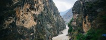
 Tiger Leaping Gorge
 Stone Forest
 Yunnan-Tibet
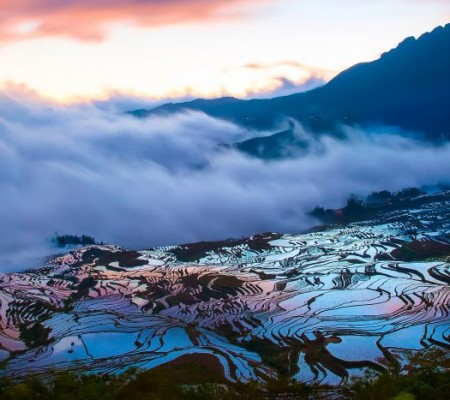
 Hani Rice Terraces
 Kunming
 Lijiang
 Shangri-la
 Dali
Dali
 XishuangBanna
 Honghe
 Kunming
 Lijiang
 Shangri-la
 Yuanyang Rice Terraces
 Nujiang
 XishuangBanna
 Spring City Golf
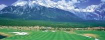
 Snow Mountain Golf
 Stone Mountain Golf


Heifeng Mountain in Anning City, Kunming
Heifeng Mountain (黑风山), located in Mingyihe Township, Bajie Township, and Xianjie Township of Anning City (安宁市), is a popular destination for Kunming residents seeking weekend relaxation and outdoor activities. Approximately 60 kilometers from downtown Kunming, the mountain ranges from north to south, with peaks soaring and rolling over an area of more than 100 square kilometers. The average elevation is 2,500 meters, with the highest peak reaching 2,617 meters, making it the tallest mountain in Anning City and a boundary between Anning City and Yimen County (易门县) in Yuxi District. It is also one of the ten highest peaks in Kunming.
Scenic Views and Accessibility
Visitors can drive under the blue sky and white clouds in off-road vehicles, while the landscape includes deep pits left after phosphate mining. From late December to mid-June, the area is designated as a forest fire prevention zone, prohibiting entry. Other times coincide with the rainy season, allowing access through various forest fire checkpoints. A drive from Kunming takes less than an hour to reach Caopu Town (草铺镇) in Anning, where numerous forks lead to routes encircling Heifeng Mountain. Visitors can navigate towards the phosphate mines, Wangjiatan Reservoir (王家滩水库), or access from Liujie Town (六街镇) or Bajie Town (八街镇).
Flora and Outdoor Activities
The slopes are adorned with alpine rhododendrons (高山杜鹃花), while off-road motorcycle enthusiasts tackle the Hillary Trail. For outdoor sports enthusiasts, the rugged terrain is ideal for off-road adventures, and hikers favor it as a top choice for long-distance trekking. The roads, mainly constructed as fire access routes, are wide but comprised of mud and stones. Caution is advised, especially after rain, as the roads can be slippery and steep, with deep ditches formed by water runoff posing risks for vehicles.
Notable Geological Features
Heifeng Mountain’s name comes from the lack of sunlight in the valleys. It features rugged terrain with steep elevation differences; the eastern side rises 720 meters, while the western valley, known as Bahe (扒河), has a difference of 1,020 meters, characterized by deeply incised middle mountain landscapes. The mountain is largely covered in small pine forests, with evergreen broadleaf forests and thorny shrubs in the valleys. Over ten valleys, including famous ones like Laoyangqing (老羊箐), Zongdianqing (棕垫箐), and Baiwuqing (柏木箐), are scattered in all directions. Baiwuqing, located on the main peak’s side, is approximately 3 meters wide and 1 kilometer long, allowing passage for off-road vehicles. The water level varies with rainfall, providing a refreshing experience for visitors.
Panoramic Views and Best Times to Visit
At the summit, one can enjoy breathtaking views of the surrounding mountains, where trees remain lush year-round. A lonely fire lookout tower stands at each peak, offering a perfect spot to take in the beauty, especially during spring when the alpine rhododendrons bloom. Encountering off-road enthusiasts and hikers creates a vibrant scene amidst the swirling mist, with picturesque landscapes featuring blue skies and white clouds.
As the sun sets, the evening glow paints the sky, bringing joy to those who witness it. Watching the sun sink below the horizon evokes a desire to freeze that moment in time. However, each visit feels fleeting as night falls quickly after sunset. Visitors should plan their time wisely and outline their route down. After descending, they can enjoy local delicacies, such as wild mushrooms in Yimen (易门) or local cuisine in Liujie or Bajie towns.
Named due to its profile resembling to a reverse copper basin, the mountain is the origin of the drinking water of the locals. Legend goes that the water at the lowest place of the main peak never dried up because there used to be a golden basin which was then taken away by an avaricious man resulting in the dried-up of the water.
Highest altitude: 2,817 metres
Duration: one day
Trekking mileage: 11 km
Route: 50 km from Kunming; Kunming-Zhebei Town (Fumin)


