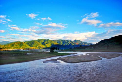
Kuke River in Baoshan and Lincang
Chinese Name: 枯柯河
English Name: Kuke River Rafting in Baoshan and Lincang
Guke River is a tributary of the Nujiang River, also known as the Mengboluo River, named after the Guke Dam it flows through. In the Dai language, “Meng” means place, “Bo” means spring, and “Luo” means forest, which translates to “river in a large forested area.” Located in the western part of Yunnan Province, Guke River originates from the west side of Monkey Stone Karst Mountain in Laoying Township, Baoshan City. It flows south through Baoshan City and is known as Baoshan East River until it emerges after 1.3 kilometers in the southeast of Baoshan, entering Changning County. It continues south through Guke Dam and Wandiang Dam, known as Guke River and Wandiang River, and after merging with Yongkang River, it is called Mengboluo River between Yongde County and Shidian County, finally flowing southwest into the Nujiang River. It stretches 208 kilometers with a basin area of 3,550 square kilometers. The average annual flow rate is 77.4 cubic meters per second, with a maximum flow of 5.8 cubic meters per second and a minimum flow of 744 cubic meters per second. The river features alternating gorges and wide valleys and is an important irrigation water source. The lower reaches of the river are characterized by wide valleys that facilitate irrigation. Several power stations are built along the river, and its major tributaries include Yongkang River and Da Mengtong River.
The Mengboluo River is one of the significant rivers in the Nujiang River system. The Changning section is locally referred to as Guke River. The three townships it passes through are major subtropical river valley crop production areas in Changning, forming an industrial pattern of “summer grains and winter vegetables.” After the beginning of autumn, rice fields in Kejie Dam, located along the Mengboluo River in Changning County, Baoshan City, welcome the harvest season. The golden rice fields shimmer under the sunlight, creating a scene of bustling harvest with the fragrance of rice filling the air.
Kejie Hot Spring Town
Kejie Town, located in the upper reaches of the Guke River basin in the western part of Yunnan, is the first stop on the Changbao Expressway when entering Changning from Longyang District. It serves as a key transportation hub for Baoshan and Dehong traveling to Changning and Lincang. It takes only 20 minutes to travel from Longyang District to Kejie.
The Kejie River basin is known as a “natural greenhouse” and is an important base for pollution-free fruit and vegetable production in southwestern Yunnan. Kejie is also the first stop of Xu Xiake’s visit to Changning, as detailed in his travel notes.
Baoshan Changning: Cotton Tree Blossoms along Guke River
In early spring, the Guke River, located in the dry and hot river valley area of Changning County, Baoshan City, again welcomes the beautiful blooming of cotton trees. Walking through Wandiang Dam, the bright red blossoms in the lush green shadows stand out, creating a spectacular view of spring. The blooming cotton flowers resemble red clouds or fiery flames. Cotton trees are much taller than other trees and their vibrant red flowers make them a prominent feature in the spring countryside. In Dai Village Wandiang, before the flowers of other species bloom, the cotton flowers have already burst into bloom, igniting the passion of spring and creating a unique and beautiful landscape. Locals have a sense of reverence and affection for cotton flowers; not only can the blooming flowers be eaten, but the fluffy flower fibers are also collected to make pillows.
By the Guke River, young people pick up the red flowers under rows of flowering trees, take photos with their phones, and sweet smiles bloom with the flowers in the spring breeze. Nearby, elderly people collect the red blooms in bamboo baskets, while children chase after the petals in the wind, enjoying the spring breeze along with the cotton flowers.
Fruit Paradise along Guke River: Wandiang Dai Ethnic Township
Wandiang is a “gem” set along the Guke River in Changning, where the Dai ethnic group resides, and is affectionately known as Dai Village. Situated in a low-temperature river valley with a three-dimensional climate, it has high accumulated temperatures and a frost-free period, making it a natural greenhouse. From an aerial view, the Guke River (also known as Wandiang River or Mengboluo River) flows like a jade belt from north to south, passing through Wandiang Dam, crossing Chain Bridge, entering Shidian Old Town Dam, and finally joining the Nujiang River. The best viewpoint for experiencing the climatic changes and viewing Wandiang Dam is to travel east along Yao Bay Road from Yaozhen Town in Shidian.
Moringa – Sour Horn – Mango
The Guke River divides Wandiang into upper and lower dams at the steep Jiepai Mountain Gorge. The soil is deep, loose, and fertile, with excellent water, light, and heat conditions, providing the perfect environment for tropical plants to thrive.
Moringa, knifewood, phoenix-tail bamboo, palm trees, large-leaf banyan, small-leaf banyan, moringa, sour horn, mango, cow stomach fruit, and sour jujube plum all thrive in Wandiang, adorning the town, villages, fields, and riverbanks with lush greenery and abundant fruit, making the area incredibly charming and attractive.
Wandian Culinary Tour
Due to high temperatures and humidity, local cuisine in Wandian is closely related to the climate, featuring flavors of sour, spicy, bitter, and fragrant. Here, you can taste unique Dai dishes such as Dai-style salad, Pa-ha fried eggs, bamboo shoots with snails, stir-fried bitter seeds, pickled vegetables, fire-grilled meat with tofu skin, fried yellow waist bee larvae, sour ant mixed with beef, and honey-coated dishes. You can also enjoy green ecological beef flavored with sugarcane leaves, with beef steak mixed with millet chili and other condiments, creating a spicy and exciting taste experience.

 7 Days GolfingTour
 8 Days Group Tour
 8 Days Yunnan Tour
 7 Days Shangri La Hiking
 11 Days Yunnan Tour
 6 Days Yuanyang Terraces
 11 Days Yunnan Tour
 8 Days South Yunnan
 7 Days Tea Tour
 8 Days Muslim Tour
 12 Days Self-Driving
 4 Days Haba Climbing
 Tiger Leaping Gorge
 Stone Forest
 Yunnan-Tibet
 Hani Rice Terraces
 Kunming
 Lijiang
 Shangri-la
 Dali
Dali
 XishuangBanna
 Honghe
 Kunming
 Lijiang
 Shangri-la
 Yuanyang Rice Terraces
 Nujiang
 XishuangBanna
 Spring City Golf
 Snow Mountain Golf
 Stone Mountain Golf


