 7 Days GolfingTour
 8 Days Group Tour
 8 Days Yunnan Tour
 7 Days Shangri La Hiking
 11 Days Yunnan Tour
 6 Days Yuanyang Terraces
 11 Days Yunnan Tour
 8 Days South Yunnan
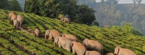
 7 Days Tea Tour
 8 Days Muslim Tour
 12 Days Self-Driving
 4 Days Haba Climbing
 Tiger Leaping Gorge
 Stone Forest
 Yunnan-Tibet
 Hani Rice Terraces
 Kunming
 Lijiang
 Shangri-la
 Dali
Dali
 XishuangBanna
 Honghe
 Kunming
 Lijiang
 Shangri-la
 Yuanyang Rice Terraces
 Nujiang
 XishuangBanna
 Spring City Golf
 Snow Mountain Golf
 Stone Mountain Golf


Location Map of Yongping County in Yunnan
Yongping County (永平县) is located in the western part of Dali Bai Autonomous Prefecture (大理白族自治州), Yunnan Province, on the eastern bank of the Lancang River (澜沧江). It is known as the “western gateway” of Dali Bai Autonomous Prefecture (大理白族自治州).
Geographic Coordinates:
- Latitude: Approximately 25°05′ N
- Longitude: Approximately 99°22′ E
Surrounding Areas:
- East: Borders Yangbi Yi Autonomous County (漾濞彝族自治县) and Weishan Yi and Hui Autonomous County (巍山彝族回族自治县).
- South: Borders Changning County (昌宁县).
- West: Separated by the Lancang River (澜沧江) from Baoshan City (保山市).
- North: Borders Yunlong County (云龙县).
The county seat is Bonan Town (博南镇), located 89 kilometers east of Dali City (大理市) and 76 kilometers west of Baoshan City (保山市).
Geographical Features:
- The county lies between the Bona Mountains (博南山) and the Yuntai Mountains (云台山).
- The terrain is higher in the northwest and lower in the southeast, with overlapping mountains and deep river valleys.
- The altitude range in Yongping County (永平县) is significant, with the highest point at 2,933 meters and the lowest point at 1,130 meters. The county seat is at an elevation of 1,620 meters.
- The main river is the Yinjiang River (银江河), which runs through the county and flows into the Lancang River (澜沧江).
Yongping County (永平县) serves as an important transport hub, historically linking central Yunnan (云南) to Baoshan (保山), Nujiang (怒江), Dehong (德宏), and other regions, as well as acting as a gateway to Myanmar (缅甸), India (印度), and other South Asian countries.


