 7 Days GolfingTour
 8 Days Group Tour
 8 Days Yunnan Tour
 7 Days Shangri La Hiking
 11 Days Yunnan Tour
 6 Days Yuanyang Terraces
 11 Days Yunnan Tour
 8 Days South Yunnan
 7 Days Tea Tour
 8 Days Muslim Tour
 12 Days Self-Driving
 4 Days Haba Climbing
 Tiger Leaping Gorge
 Stone Forest
 Yunnan-Tibet
 Hani Rice Terraces
 Kunming
 Lijiang
 Shangri-la
 Dali
Dali
 XishuangBanna
 Honghe
 Kunming
 Lijiang
 Shangri-la
 Yuanyang Rice Terraces
 Nujiang
 XishuangBanna
 Spring City Golf
 Snow Mountain Golf
 Stone Mountain Golf


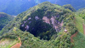
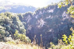
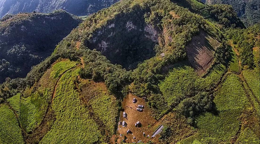
Tiankeng Dolines in Cangyuan County, Lincang
Chinese Name: 沧源天坑
English Name: Tiankeng Dolines in Cangyuan County
Keywords: Tiankeng Dolines in Cangyuan,Cangyuan attractions, Cangyuan tours, karst landform
Location: These Tiankeng Dolines are located at the middle of the Cliff Painting Valley in Cangyuan
Admission Fee: Free
Opening Hours: All the day
Tiankeng Dolines in Cangyuan County
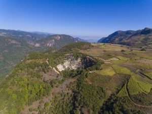
Tiankeng is called funnel karst landform in geography, Tiankeng Dolines in Cangyuan County is the biggest one in Yunnan province. Tiankeng Group of Cangyuan County in China is a large, steep-walled, pit-like, negative, karst landform that opened from beneath towards surface, with both its depth and its diameter more than 100 m to several hundred meters, developed in a great thickness of continuous soluble rocks within the aquifer vadose zone above deeply buried water table and connecting with an active cave river at its foot. It is also characterized by its tourism values of rarity, grandeur and spectacular magnificence, and by its special ecological environment.Apart from this biggest one in front of us, there are other 6 tiankeng lie in same level line. It was said that once a man climbed down the cliff, seeing an unfathomable cave. Inside the cave there are lakes, waterfall and a great number of stalactites.
What is Doline or Tiankeng?
A doline, sink or sinkhole is a closed depression draining underground in karst areas. It can be cylindrical, conical, bowl- or dish-shaped. The diametre ranges from a few to many hundreds of meters. There are two different mechanisms for the forming of dolines:
Solution
The corrosive solution of limestone by rainwater is very high in the area fo crack, allowing the water to run into the rock. This normally forms the bowlshaped type of dolines.
The solution produces large amouts of clay (depending on the pureness of the limestone). This clay is water resistant and sometimes plugs the drainage, so little lakes of rain water can sometimes be found in dolines, a rare thing in waterless karst areas.
Collapse
When a cave grows, there may be a point where the roof of a cavern is not stable enough. This results in (several) collapses that shape the roof like a dome. This process runs out, when the shape is able to hold the weight of overlying rocks.
If the impact of this collapse reaches the surface, if the overlying layers are too thin then the ceiling collapses and a doline is formed. The doline is often a natural entrance to the cave.
Discoveries of Karst Tiankengs in China
Karst tiankengs have been known as “large collapse dolines” for a long time, since small number of them have been discovered around the world, but they have received little attention in academic research. In China, the large collapse dolines that were first widely known are in Sichuan Province. Then more such dolines were reported in Guangxi Province, mostly as marvelous natural scenery. From early 90s up to now, a series of karst tiankengs were found and studied in China by Sino-foreign cave expeditions and other many research projects sponsored by Geological Society of China and Institute of Karst Geology of the Chinese Academy of Geological Science. It is during this period of extensive research that the name “karst tiankeng” is formally proposed and widely recognized as the right terminology for this unique geological formation.
There are about 50 karst tiankengs known in China. Of these, 3 are giant tiankengs more than 500 m deep and 500 m in entrance diameter – Xiaozhai Tiankeng in Fengjie of Sichuan, Dashiwei Tiankeng in Leye of Guangxi and Haolong Tiankeng in Bama of Guangxi. There are also 5 large tiankengs more than 300 m in depth and entrance diameter.
Distinction between karst dolines and karst tiankengs
Karst doline is one of the most familiar and distinctive landforms in karst terrains. There are several doline types that form in the soluble rocks, including the corrosion doline, the permeable doline, the suffosion doline and the collapse doline. Of collapse dolines, there are karst bedrock collapses and also collapses in insoluble rock that covers a buried karst, but the size of all these do not match the size of a tiankeng. To date, dolines found in carbonate rocks have diameters and depths up to about 100 m. Steep-walled, pit platform is different from all the main doline types, they differ not only in size but also in their development mechanisms and conditions. Why is a large karst doline now named as a karst tiankeng? The basic reasons are:
A tainkeng develops in special environmental conditions that integrates aspects of geology, geomorphology and hydrogeology, but a common doline develops in a much wider range of karst environments. Consequently, dolines and collapse dolines are widespread while karst tiankengs are very few within the global picture of karst.
A tiankeng differs greatly from dolines and collapse dolines in its development and erosion mechanisms. The common collapse doline forms by dissolution and suffosion in normal geological and hydrodynamic environments. Collapse tiankengs have developed through an unusual hydrodynamic combination of erosion, dissolution and collapse where three evolutionary stages may be distinguished – from a cave river to an underground cavern to a tiankeng open to the surface – this is not comparable.
A tiankeng is very different from a normal doline in size. It is very large and broad.
Tiankeng have close relationships with the regional development of cave river systems, and their distribution, evolution, age and development rates are not comparable to those of common karst dolines.
Genetic Types and main features of karst tiankengs
Current research suggests that tiankengs developed in carbonate rocks may be divided into two types-collapse tiankengs and erosional tiankengs. The former is much more widespread and numerous than the latter.
Collapse tiankengs
Collapse tiankengs formed in soluble rocks in which massive amounts of rock material were dissolved and eroded away at depth by an intensely dynamic underground drainage system, notably by large cave river system. Under specific geologic and hydrogeological conditions, a cavern evolved as its roof failed gradually while the falling rock debris was carried away by water, until it opened to the ground surface.
Erosional tiankengs
Erosional tiankengs developed in the vadose zone of soluble rocks by allogenic water eroding and dissolving the rock in its vertical descent from the surface. They are very rare because of their special environmental conditions.
Collapse and erosional tiankengs have some features basically in common, but also have some important differences in their development conditions:
A great and continuous thickness of soluble rocks
Solution sedimentary rock (generally carbonate rocks in China) is the first requirement for tiankeng development. Clearly, large and deep tiankengs developed within large thickness of soluble rock unbroken by any significant impermeable intermediate beds, so allowing the establishment of a unified vadose aquifer zone.
A deep vadose zone in soluble rocks
Karst tiankengs largely developed in the vadose zone of an aquifer above a deeply buried water table, where the thickness of the vadose zone is nearly equal to or greater than the depth of the tiankeng. Tectonic uplift and rejuvenation caused entrenchment of the surface rivers and a major lowering of the regional water table, thereby increasing the thickness of the vadose zone. Tiankengs are most common in areas of neotectonic uplift.
A favorable geological structure
The two kinds of karst tiankeng formed mainly in karst regions with gently dipping or horizontal rocks, where the soluble rocks have wide outcrops. Structural fissures, notably long and deep faults and vertical joints allow development of a strong hydrodynamic system in the aquifer. A structure with gently dipping beds and networks of joints and faults favours progressive breakdown of the roof of large cave chambers at depth. Dipping beds are eroded to outcrops with long contacts between soluble rocks and non-soluble rocks, that favour development of erosional tiankengs by allogenic drainage, such as at Qingkou Tiankeng.
A highly active hydrodynamic system with underground conduit flow in cave rivers
A tiankeng is the largest closed and negative landform in karst, involving the removal of 1-1000 million cubic meters of rock by breakdown, dissolution and fluvial transport. It definitely requires a very strong input-output hydrodynamic system, in the form of active conduit flow within a cave river system in the karst aquifer. Known tiankengs have developed in association with major karst underground river systems. The cave river is the critical factor in tiankeng development, especially for erosional tiankengs where it is the result of the tiankeng development and not its precodition.
Favorable climate and hydrogeology
A humid rainy climate supplies plentiful rainfall for dissolution and river flow, and encourages high intensity and high rate of tiankeng development in a karst. Tiankeng distribution is related to zones of humid climate and abundant precipitation.
These environmental factors are all optimally developed in the karst of southern China, especially in the high-relief cone karst areas – which include the most important tiankeng sites in the world.
Karst tiankengs provide data for karsification intensities and rates, and offer a new way to study time-scales of karst geological process. It is suggested that the tiankengs in China are the youngest and the largest negative landforms of the karst. Research is directed into the high intensities and rates of karstification and the relatively the geologic age of the tiankengs, and it is suggested that the tiankengs in China formed mainly in the late Pleistocene since 128,000 years ago.
The status of Chinese tiankengs within the karst of the world
As independent and significant karst landforms, tiankengs are not common around the world, and are infrequently studied. The largest tiankengs outside China known to date are mainly distributed through the lower latitudes, including New Britain (Papua New Guinea), Sarawak (Malaysia) and Mexico, and are few in number. Smaller tiankengs are also know in Europe close to the Mediterranean coasts. Compared with those abroad, tiankengs in China possesses significant status within the world’s karst because of the following features:
Large numbers and clustered distribution
Tiankeng in China occur mainly in the south, within the drainage basins of the Yangtze and Peal Rivers , where there are 6 major tiankengs nearly 50 in total. Many are grouped within the same drainage basins or on the same cave river systems.
Large dimensions
In nearly 50 tiankengs found to date, there are 3 oversize tiankengs (Xiaozhai, Dashiwei and Haolong), whose entrance diameter and depth are generally above 500-600 m, and there are tens of large tiankengs more than 300 m in entrance diameter and depth.Perfect formation, beautiful scenery and high values of aesthetics and sightseeing.
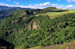
Tiankengs in China are mostly surrounded by precipitous cliffs, are very deep and are covered by original forest on their floors. They are characterized by their grandeur, sheer spectacle, peculiarity, and mystery. They are also valued for their aesthetics and sightseeing interest, and some including Dashiwei in Leye are open to tourism and visitors.
Important value for scientific research
This includes the integrity of the geomorphological systems of tiankengs, the difference between the two different genetic types, and the worldwide rarity of the erosional tiankengs. Tiankengs also promote active karst research. For example, the Dashiwei tiankeng group, known for its Museum of Collapse Tiankengs, is the world’s best location for tiankeng research. It has active examples of tiankengs in different stages of development and in contrasting landform environments. It lies in a typical high-relief cone karst terrain in southern China, within the Bailong subterranean river drainage basin of 835 km2, with a subtropical monsoon climate, and annual average of precipitation of 130-170 cm.
But the professional insiders warn that these Tiankengs are not constructed and developed completely, visitors must pay extra attention to the safety in these areas. Up to now, the secret of these Tiankeng Dolines are just dug part of it, with a deeper exploration more and more fancy topography and species will be found.
Attraction Transportation: We can take the shuttle bus from the bus station of the county
Attraction Travel Tips:
·It is quite dangerous around the Tiankeng Dolines, please be careful about walking steps.
·Prepare enough clothes and food, it is definitely a hard journey.
The Location map of Tiankeng Dolines in Cangyuan County, Lincang


