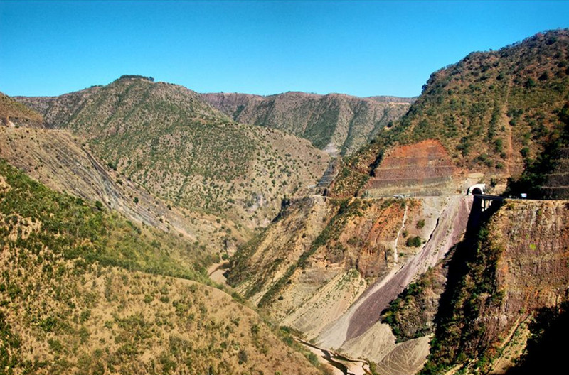
Longchuanjiang River in Chuxiong
Chinese Name:楚雄市龙川江
English Name: Longchuanjiang River in Chuxiong
Overview
Longchuan River, a first-level tributary of the Jinsha River on the southern bank, has abundant water sources. It originates from the Puzhao Pond on the east side of Tianzi Temple Slope in Nanhua County, Chuxiong Yi Autonomous Prefecture, Yunnan Province. The river flows east through Nanhua County and Chuxiong City, then turns north into Luxi County and Yuanmou County, crossing the Yuanmou Basin before merging into the Jinsha River in Jiangbian Township, northern Yuanmou. The total length of the river is approximately 246 kilometers, with a watershed area of 9,240.7 square kilometers. The elevation difference between the source and the mouth is over 1,600 meters, with an average riverbed slope of 4.8‰ and an average watershed altitude of 1,992 meters. The watershed is predominantly mountainous and hilly, making up 95% of the area, with river valleys and shallow hills comprising about 5%.
Historical Names
Longchuan River was known as Yanshui during the Han Dynasty. The “Shuijingzhu” notes: “Yanshui enters the Jinsha River near Sanxian County (now Huili, Sichuan).” It was first named Longchuan River during the Ming Dynasty. The Qing Dynasty’s “Yitongzhi” described the river as follows: “Longchuan River, upstream known as Bailong River, flows from the west of Zhennan Prefecture (Nanhua County) to the southeast, passing through the southern part of the prefecture, also called Ping Yi Chuan, and continues southeast through the northern part of the prefecture, passing Qingshan and continuing as E Lu Chuan, then turning northeast through Dingyuan County (now Mouding County) to the southeast. It exits below Shimen Mountain and joins with the south river of Dingyuan County (including Mouding River) before continuing northeast through Guangtong County as Dazhang River, then north through Heijingsi and eventually into the Yuanmou County boundary of Wuding Prefecture, merging into the Jinsha River.” Today, different sections of Longchuan River have various names: the upper reaches in Nanhua County are called Bailong River, flowing into Chuxiong City as Longchuan River or Longchuan Jiang, and in the Heijing area of Mouding County, it is known as Heijing Dazhang River, while the lower reaches are again referred to as Longchuan Jiang. The flow direction of the river is northwest-southeast above Chuxiong City and south-north into the main stream below. [1]
Source and Tributaries
The river source area is mainly mountainous with developed river networks. The main stream is formed by the convergence of various mountain streams, with significant rivers such as Lao Chang River. The main stream flows through three basins: Nanhua, Chuxiong, and Yuanmou, with a wide, shallow, and curved riverbed and gentle slope. Other river sections are valley areas where the main rivers flowing into Longchuan River include Qingling River and Pudeng River.
Hydrology and Climate
Longchuan River is a mountain rain-season river, with runoff replenished by rainfall. The watershed is influenced by the dry-hot valleys of the Jinsha River, characterized by a later onset and earlier end of the rainy season compared to other regions in Yunnan. The average annual rainfall is 800 mm, which is 64% of the Yunnan average, with particularly scarce rainfall during the dry season and less rainfall during the rainy season compared to other areas. The annual variability in rainfall is the highest in Yunnan, mainly distributed in Yuanmou, Yongren, Mouding, and Yao’an areas.
River Gradient and Water Resources
The natural drop of Longchuan River is 1,474 meters, with an average gradient of 5.65‰. The average annual flow is 52.2 cubic meters per second, with a theoretical hydropower potential of about 230,000 kilowatts. Major hydropower stations include Dahai Bo, Luomozuo, Dishui Jing, Shang Shen, and Hujiao Beach. [1]
Agricultural and Economic Impact
The basin has concentrated agricultural land, with major basins including Nanhua Basin, Chuxiong Basin, Mouding Basin, Yao’an Basin, Dayao Basin, Yuanmou Basin, and Yongren Basin. The total land area of the basins is 1,547 square kilometers, accounting for 55.6% of the entire basin area. The cultivated land area in these basins is 768,000 mu, representing 60% of the total cultivated land of 1,274,000 mu in the basin. The degree of irrigation development in the basin is about 60%. The capital of Chuxiong Yi Autonomous Prefecture is located within this basin, making it a major political, economic, and cultural center in central Yunnan.
Geographic Location
The Longchuan River basin is situated in the transitional zone between the Hengduan Mountains and the Yunnan-Guizhou Plateau. The majority of the basin features a medium mountain and hilly landform. The upper and middle reaches are characterized by high mountains, steep slopes, and deeply cut riverbeds with significant topographical variations. The lower reaches have a gentler terrain, forming a basin.
Hydrological Climate
The Longchuan River basin experiences a low-latitude plateau monsoon climate. In summer and autumn, it is affected by warm and humid air currents from the Bay of Bengal and the North Bay. In winter and spring, it is influenced by dry warm air currents from the Indian mainland and cold air from the north. The climate types in the basin include subtropical monsoon, northern tropical, northern subtropical, and southern subtropical climates, with distinct wet and dry seasons, large daily temperature variations, and small annual temperature differences. The annual average temperature ranges from 14.8 to 21.9°C.
The Longchuan River has distinct wet and dry seasons with relatively low rainfall. The rainiest area in the basin is around Wutai Mountain in Nanhua County, with an annual rainfall of up to 1,600 mm. The driest area is in the Jinsha River valley, mainly in Jiangyi Township and Jiangbian Township in Yuanmou County, with annual rainfall of less than 800 mm.

 7 Days GolfingTour
 8 Days Group Tour
 8 Days Yunnan Tour
 7 Days Shangri La Hiking
 11 Days Yunnan Tour
 6 Days Yuanyang Terraces
 11 Days Yunnan Tour
 8 Days South Yunnan
 7 Days Tea Tour
 8 Days Muslim Tour
 12 Days Self-Driving
 4 Days Haba Climbing
 Tiger Leaping Gorge
 Stone Forest
 Yunnan-Tibet
 Hani Rice Terraces
 Kunming
 Lijiang
 Shangri-la
 Dali
Dali
 XishuangBanna
 Honghe
 Kunming
 Lijiang
 Shangri-la
 Yuanyang Rice Terraces
 Nujiang
 XishuangBanna
 Spring City Golf
 Snow Mountain Golf
 Stone Mountain Golf


